A Guided Tour of Patagonia
02/09/2020 - 02/21/2020
Mark Seaver
My wife and I joined family members and others for a small group (16 people) tour of Patagonia, sponsored by the National Geographic and conducted by G Adventures. While this was not designed as photographic tour, the sights we saw included some wonderful terrain and close encounters with wildlife. Overall, the tour alternated between a day of travel and a day of exploring, with an emphasis on the natural wonders of Patagonia. Each day of exploring offered at least two options with local guides to describe what we were seeing.
The locations outside of Buenas Aires that we visited were:
- San Carlos de Bariloche (Bariloche) in the Patagonia lakes region of Argentina,
- Puerto Varas in the lakes region of Chile,
- Torres del Paine, Chile
- El Calafate, Argentina, and
- Ushuaia, Tierra del Fuego, Argentina.
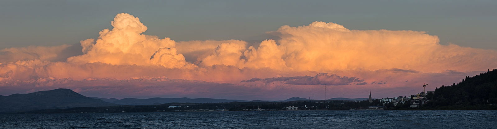
San Carlos de Bariloche is located on the south side of lake Nahuel Huapi, which is part of a large national park of the same name including the lake and the surrounding mountains to the north. Our group was offered horseback riding, hiking, and kayaking although it’s clear that with some additional driving there was much more in this area to explore. All of the local lakes were created by glaciers and there are still glaciers on the slopes of several local mountains, many of which are volcanoes. The tallest mountain, Tronador, is clearly a stratovolcano reminiscent of the similar volcanos in the Pacific northwest (Rainier, Adams, Hood, etc.). While I couldn’t get any pictures of it due to heavy cloud cover, my view out the airplane window showed it to be much taller than it’s surroundings and almost completely covered in ice and snow. The photo below was taken when I left a group dinner, dashed across a busy two lane highway (drivers in Patagonia were amazingly tolerant and even considerate of pedestrians), and shot this sunset panorama (4 shots) of a thunderstorm in the distance that later produced some distant lightning but since the clouds were to our east, the rain never reached our outdoor dining location.
A moderately strenuous hike took us to a knoll on the side of a mountain with a nice view of a smaller lake and the surrounding mountains, but it wasn’t an especially photogenic view.
The next day’s travel involved 4 bus rides and 3 ferry rides as well as a border crossing into Chile, which meant a visit to Argentinian customs upon leaving and going through Chilean customs a few miles later. The image below was taken from the ferry going from Bariloche to Puerto Blest on lake Nahuel Huapi during our first ferry ride. While the mountains were tall, green and close, I was most attracted to the beautiful blue-green water of the lake. The mostly cloudy skies seen here were common throughout most of our trip. The guide for our hike outside of Bariloche said that their best weather comes in the spring (Sept. and Oct.). However, an online weather summary suggests that the most sun is seen in late January and early February.

Puerto Varas: The trip from Bariloche to Puerto Varas covers a very well known trade route between Chile and Argentina that was heavily used in the early days of development in
Argentina and Chile. Given how onerous the trip was, roughly 4 hours of ferry rides and 7 hours of mountainous bus rides, that fact is quite surprising. In Puerto Varas we were offered the choices of, a waterfall and volcano visit, white water rafting or a trip that included a quaint fishing village and a boat ride around an island with a penguin rookery. We chose the waterfall and volcano trip, which got started early enough for some nice light, modest numbers of visitors and mist rising from the cold waters of the as the Petrohué river tumbles over and through hardened lava (top image, next page) along the flanks of the Volcano Calbuco Although Calbuco erupted with little warning in 2015
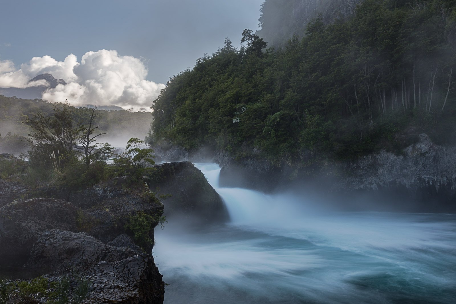
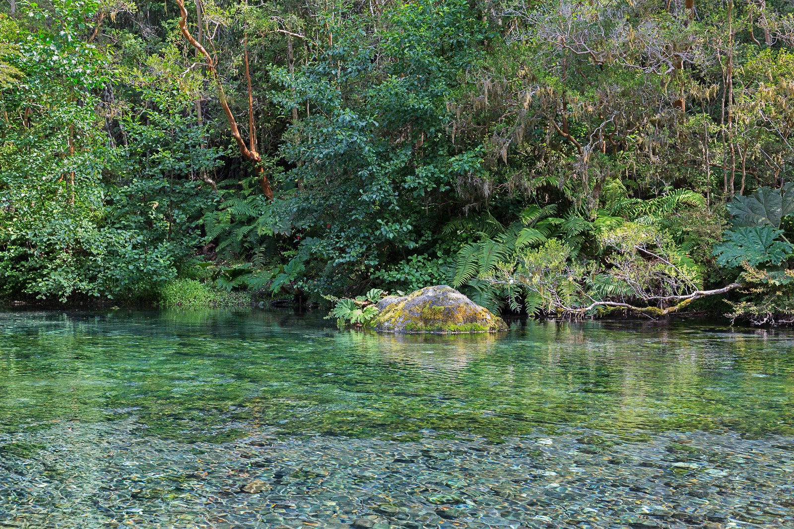
covering the area with ash, the formations around the falls are much older. As we arrived, the nearby volcano Osorno could be seen clearly, but it quickly disappeared into the gathering clouds. This is an area of temperate rain forest, similar in climate to the Pacific Northwest with lots of vegetation including trees draped with moss and crystal clear waters. The next view is a look at a branch of the Petrohué river showing delightful colors as we explored the forest adjacent to the Petrohué falls.
Torres del Paine: The peaks of Torres del Paine are well known and it’s an outstanding travel destination. A plane ride took us south from Puerto Varas to Puerto Natales with a long bus ride back north to Torres del Paine. On the way to our hotel, we stopped at a well used overlook for our first good view of the Torres del Paine. This view is along the Lago el Toro, with the three main peaks being (left to right), Paine Grande, Torres del Paine & Almirante Nieto. These three peaks are part of what’s called a massif, that is a large injection of molten magma that cools completely before it reaches the surface. The surrounding rocks (foreground hills) are all sedimentary rocks (deposited under water) covered with low growing grasses and shrubs similar to the North American short
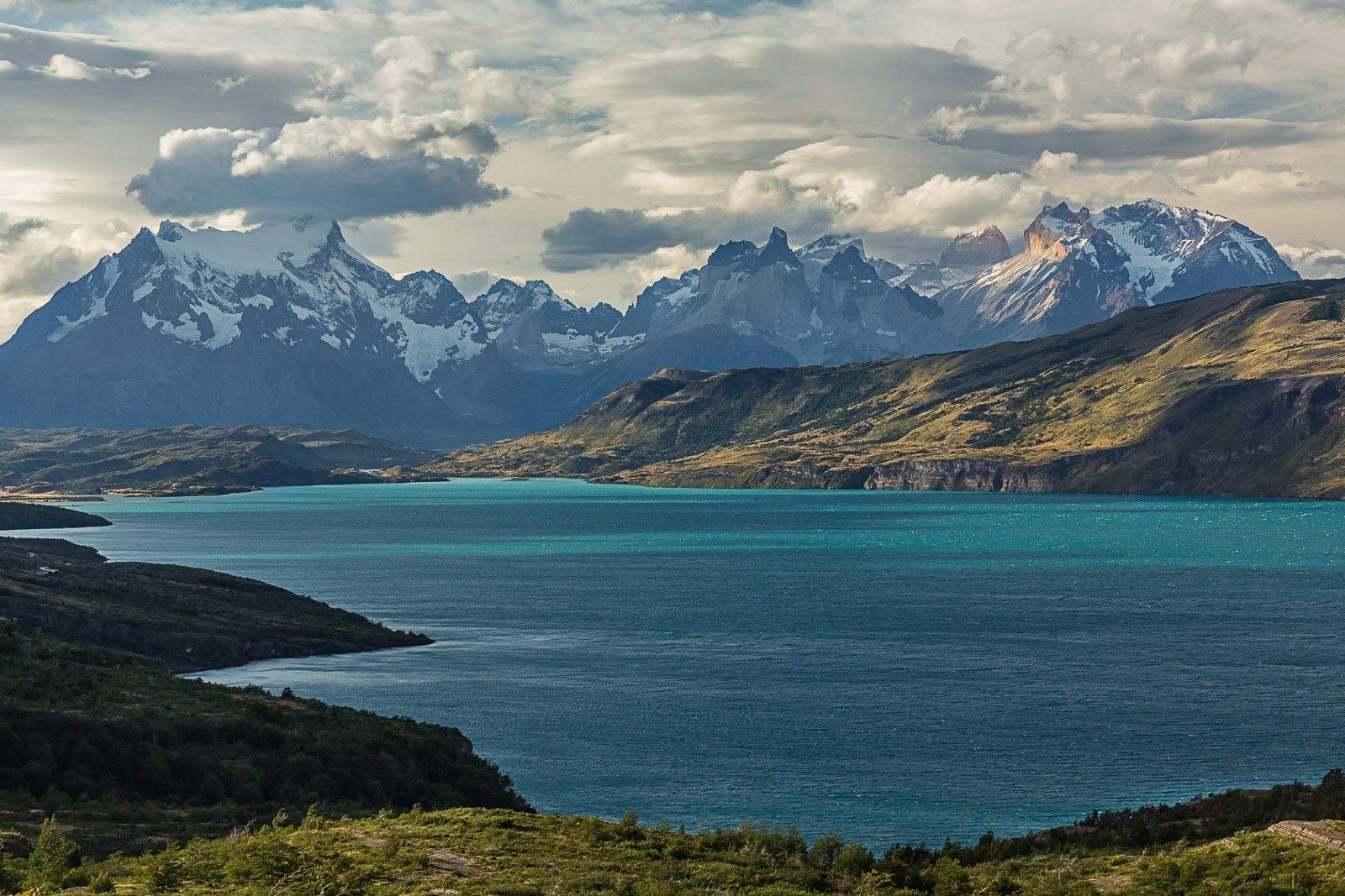
grass prairies. The rugged peaks of the massif have all been sculpted by glaciers with many glaciers both large and small still seen. There is a hiking trail that takes visitors up close to several of the glaciers and into the rugged peaks, it’s suggested that visitors set aside at least four days to hike the “W” trail.
We stayed at the hotel in Rio Serrano, which is very close to a park entrance. The panorama shows the area around our hotel (large red building a bit above and left of center) and the Grey river (runoff from the Grey Glacier) and Serrano river. The high peaks are hidden in the clouds. The next day’s excursion included very windy visits to two waterfalls, multiple fine views of the highest peaks and a distant view of the Grey Glacier. (We were told repeatedly that windy conditions are the rule, not the exception.) A close view of the Grey Glacier requires a boat ride. As we headed back to the hotel, we had the rare good luck to spot the king of Patagonia, a Puma (Mountain lion, Cougar, etc.), sitting in the prairie grasses near the road. It made a pleasant wildlife scenic that I won’t show here

El Calafate: The next day’s bus ride took us along the two long legs of a triangle, since there is no decent direct road between Torres del Paine and El Calafate. El Calafate is along the
south shore of Lago Argentino, the largest lake completely in Argentina. It’s also the closest town to the glacier Perito Moreno. A 1.5 hour bus ride from town took us to the area directly overlooking this glacier where I took this picture showing the toe and North faces of this glacier.

The channel extending just out of view to the left has regularly been blocked by ice as the glacier moves down the mountain. The waters of the lake then erode a tunnel under the ice forming an ice bridge. Eventually the ice bridge collapses. Perito Moreno is a rare glacier in that it’s size is stable, alternating between modest advances and retreats as shown by the repeated ice bridge formation and destruction. Recently this has occurred roughly every 3 years. Remnants of the ice bridge are on the near shore just out of the frame. On the south (left) side of the ridge that I’m standing on for this photo, there are ferry rides to the south face of the glacier. There you can get an up close look at the details, as seen in the next photo, along with parts of the mountains behind and a small iceberg.
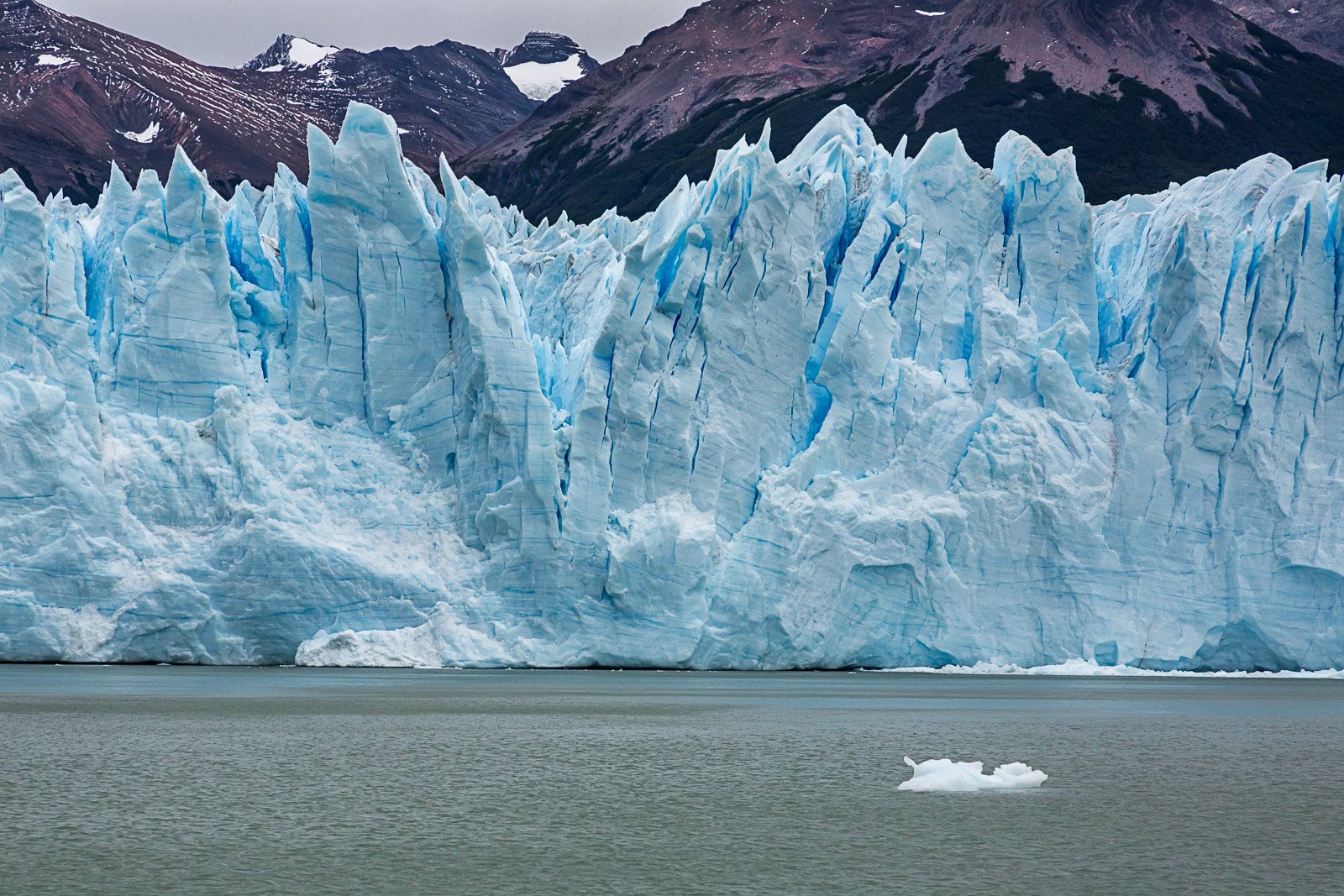
The side peaks are cut off deliberately to better emphasize the depth of the crevasses in this roughly 70 foot tall glacier.
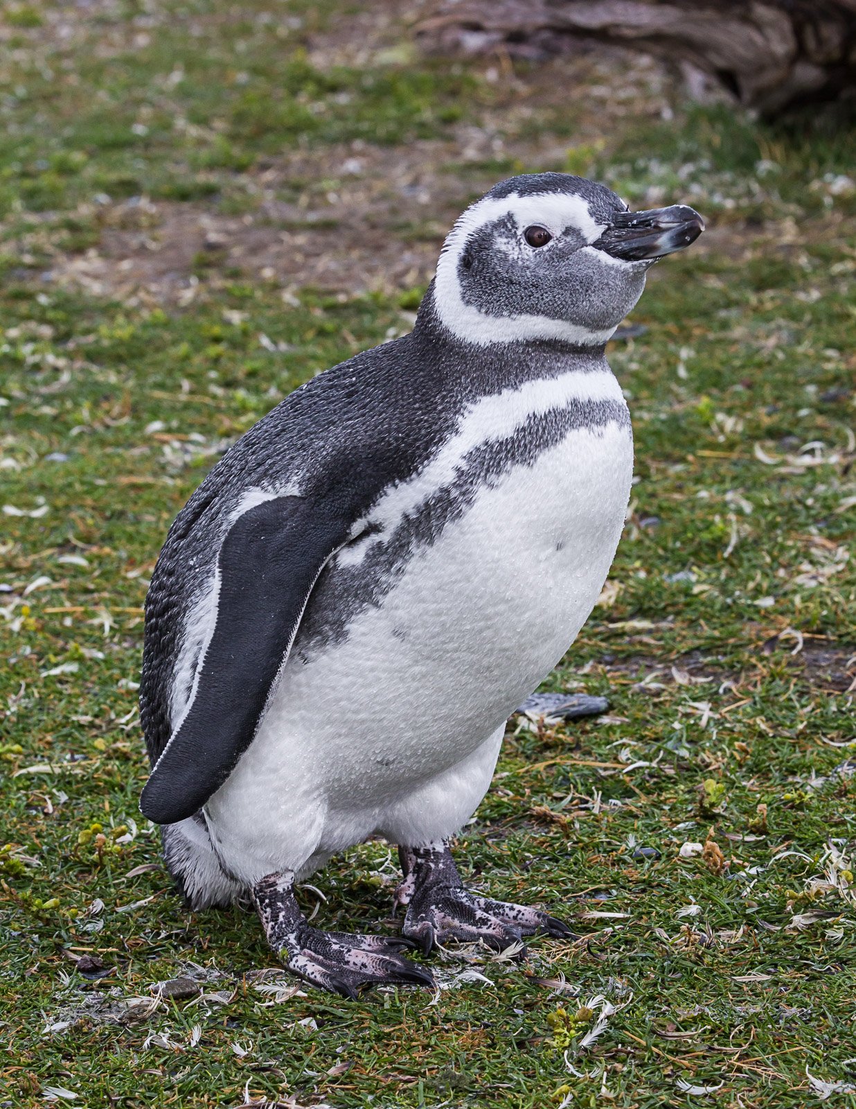
Ushuaia: This is the main Argentinian town in the Tierra del Fuego area. It’s an hour and a half plane ride from El Calafate. It borders Tierra del Fuego national park and the Beagle Channel. The group excursion was a visit to a penguin colony on a privately owned island in the Beagle Channel. This trip started with a 1.5 hour Bus ride to a small museum with lots of skeletons of sea animal (including whales) that had washed up on ranch shores. It’s operated by the land owner, who switched from raising cattle to tourism in the 1990s. From the ranch (estancia) we took a covered Zodiac ride to the Penguin rookery, spent about an hour in the midst of the colony and returned to the ranch. The return to Ushuaia involved a ferry ride along the Beagle Channel. It’s also possible to take this tour in reverse order; Ferry ride, penguins island, Bus ride. The weather was cold and rainy, with the rain during the penguin colony visit varying from steady to a light drizzle. There are three penguin species nesting on this island, the majority are Magellanic penguins, Gentoo penguins are also numerous with a single King Pair nesting for the first time this year. The size and plumage of the King penguin made it easy to spot in the crowded surroundings. As we landed, there was an amazing collection of sea birds in a feeding frenzy very close to shore dominated by Black-browed Albatross.

We had about an hour to follow a carefully marked path through the midst of the Penguin colony providing close-up views of the penguins, many of which were in various stages of molting. There were a few penguins in the middle of the path and as we slowly and carefully walked around them, they would turn their heads, carefully following our movements and showing clear curiosity. This photo shows one of the Magellanic penguins that had moved slightly away from the main mass of standing along the shore.
Upon returning to the ranch, we boarded a ferry for the trip back to Ushuaia, following the Beagle Channel. Towards the end of the return to Ushuaia, the ferry slowly circled a small island with a light house and then gave us close views of a large Cormorant colony,

which shared another small island with a group of about 10 immature South American Fur Seals. The view below shows two of the seals having a dominance “discussion”.

Overall, our leader (called a Corporate Experience Officer or CEO, ![]() ) and the people that he recruited as local tour guides were excellent. We were introduced to multiple interesting places and given lots of human and natural history. While it was not a “photographic tour”, there were some prime photo opportunities. I am very interested in return visits to several of our sites, where I’d rent a car and spend a minimum of 4 days at each location. That would provide plenty of opportunity to explore and hopefully get at least one day with the sun shining. There are more photos from this trip on my website, https://seaverphotos.zenfolio.com/p58987550 .
) and the people that he recruited as local tour guides were excellent. We were introduced to multiple interesting places and given lots of human and natural history. While it was not a “photographic tour”, there were some prime photo opportunities. I am very interested in return visits to several of our sites, where I’d rent a car and spend a minimum of 4 days at each location. That would provide plenty of opportunity to explore and hopefully get at least one day with the sun shining. There are more photos from this trip on my website, https://seaverphotos.zenfolio.com/p58987550 .
