The photographer is looking for generalized feedback about the aesthetic and technical qualities of their image.
Description
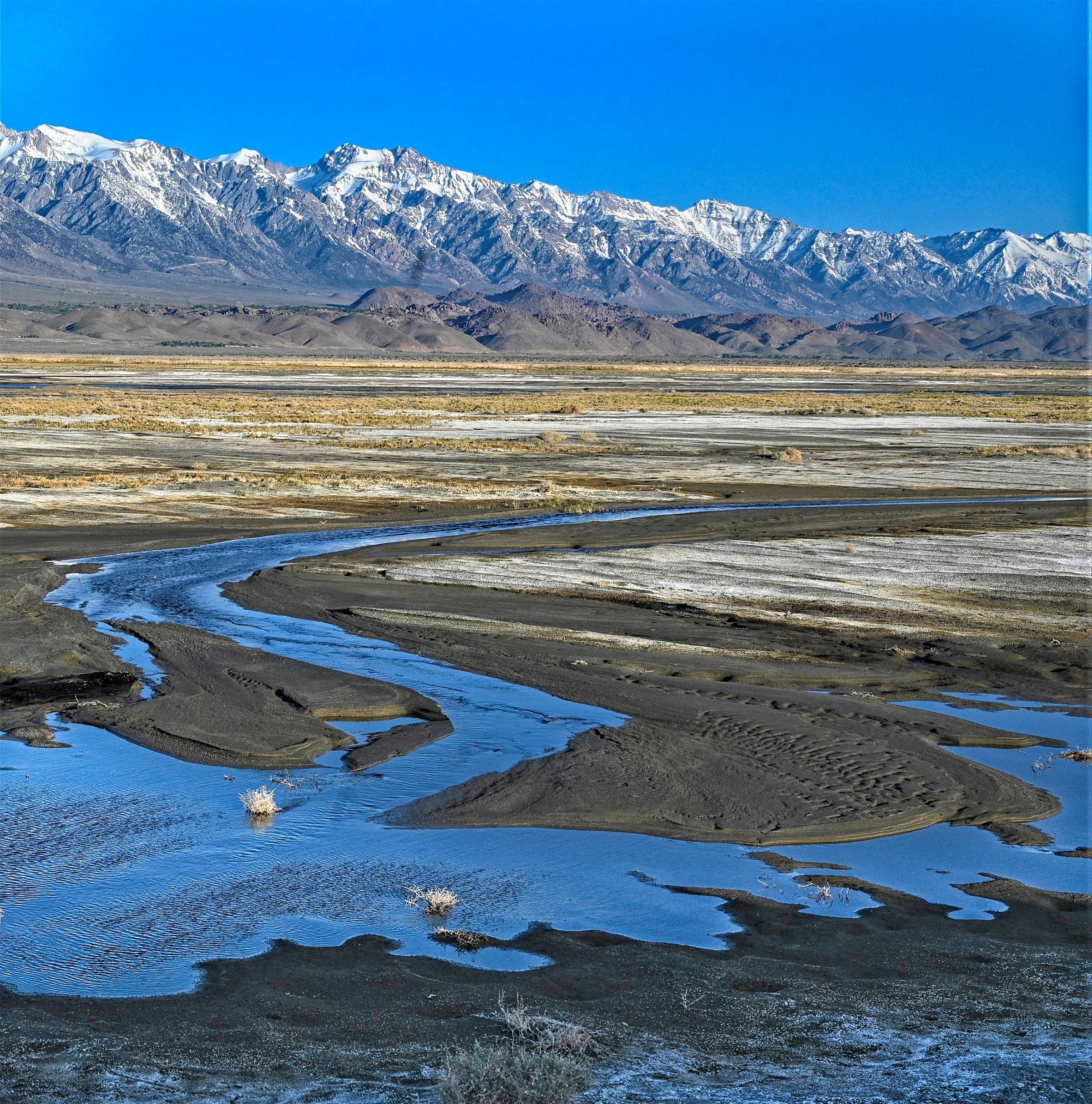
Record snowfall in the Eastern Sierra Nevada promises record runoff, and that means the Los Angeles Department of Water and Power, which has been extracting most of the water from Owens Valley for decades, will have more water than it can handle. Many longtime Owens Valley watchers are forecasting destructive runoff. The much abused but – this year – revitalized Owens River in late April was already flowing strongly into vast Owens Lake, which dried up after LA started taking all the water. I was out on the lake early to photograph birds and found the river itself, a very rare sight, filling a barren area of the lake, reclaiming a place which once held a lake some 30 feet deep.
Specific Feedback
Questions about how much foreground and background, tight crop, etc. I was up on a dike so could shoot down, filling the frame, but might have climbed down and got closer to the water. I have some panoramic crops as well, but they tend to flatten out the high peaks in the distance, source of the river.
James, a fine look at this area during this start of the upcoming MAJOR snow runoff. Lots of history behind this area on several levels. The biggest of course as you’ve outlined was and is the water diversion over the years.
James, the view looks great, with nice curves and ripples in the river, the long view across the flats and the distant, rugged peaks. I don’t think the blue reflections along the bottom are adding to the view, so I’d suggest cropping just below the water line. There’s also a bright line, a few pixels wide, along the right hand edge.
Thanks Paul. I want to go back and see the runoff at peak. I won’t be surprised if they close access to the Owens Lake bird ponds because the levees out there are being weakened by the rising waters.
I’m so glad to see this. I was there in March and it broke my heart to see the dried up lake. and to learn why it was that way. Also, judging by signs all along the river, the city of LA seems to own the Owens River as well as the lake. I love the image you posted.
Thanks Chris. LA bought up almost all the water rights in Owens Valley long ago, so they nearly killed the river simply by taking the water before it reached the river. However, the short version of what has happened in the last few decades is that a combination of legal decisions and regulatory actions have forced LA to try to restore Mono Lake in the north, refill the Owens River and mitigate all the dust caused by the drying up of Owens Lake. They must divert water they’d like to take to LA to these local environmental and health priorities. One result has been the restoration of major migratory bird habitat in Owens Lake, which you can visit and enjoy in all but the driest years (most recently at the annual Owens Lake Bird Festival). Here are some examples. What’s happening now is the huge snowpack is starting to overwhelm LA’s ability to capture all the water and send it south. Predictions vary, but a lot of people expect flooding and of course, spectacular runoff, cascades and waterfalls across the Eastern Sierra. I’ll be back to shoot it!
When I visited Mono Lake many years ago, it was gut-wrenching to read about what the water board and other authorities did the northern California in their greed for water. It was unconscionable and still is. Makes me crazy, but I hope that things can be improved somewhat. Keep the photos coming. Eastern Sierra country is spectacular.